 Maps
Maps
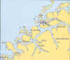
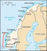 The
small part of the Norwegian coastline covered by this website is highlighted in
red on the map. Even within this area, much of the diving is unexplored. It's
easy to see why Norway is such a great place for adventurous and exploratory
divers - Narvik inside the Arctic Circle, and Molde just north of Ålesund
are the only other areas on the west coast that are visited by
significant numbers of divers.
The
small part of the Norwegian coastline covered by this website is highlighted in
red on the map. Even within this area, much of the diving is unexplored. It's
easy to see why Norway is such a great place for adventurous and exploratory
divers - Narvik inside the Arctic Circle, and Molde just north of Ålesund
are the only other areas on the west coast that are visited by
significant numbers of divers.
The dive sites are shown by symbols on six overlapping maps. Scenic sites are dots, and wreck sites are represented by a shipwreck symbol. Rolling the mouse over a symbol brings up its name, and clicking on a symbol brings up the page with the relevant diving details. Click on a map to see where the dive sites are. Reading left to right, top to bottom, the chartlets below are arranged from south to north.
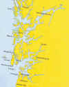
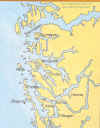
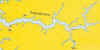
Stavanger to Bergen Bergen to Sognefjord Inner Sognefjord
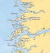
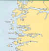
Sognefjord to Fløro Askvoll to Måløy Måløy to Ålesund